

Nimrod fortress isthe largest and most impressive fortresses on Golan heights.The frontier fortress guarded the main road from Damascus to Tyre and Tiberias during the Crusaders period. Initially fortified by the Crusaders, the present walls and towers were built by the Mamluks during the 13th C.
The fortress is located inside a National park, on a high cliff (820m above sea level), high above the ancient city of Banias. It is naturally protected by deep the gorges of the Guveta stream (north) and Sa'ar stream (south), both heading towards the Banias.
Official records say that fortress was built around 1229 by Al-Aziz 'Uthman, the younger son of Saladin, to preempt an attack on Damascus by the armies of the Sixth Crusade but huge megalithic blocks clearly show that base of fortress was built much earlier.
In 1260 the Mongols captured the castle, dismantled some of its defenses and left their ally, the son of Al-Aziz 'Uthman, in charge of it and the nearby town of Banias.After the subsequent Mamluk victory over the Mongols at the Battle of Ain Jalut, Sultan Baibars strengthened the castle and added larger towers. The fortress was given to Baibars's second-in-command, Bilik. The new governor started the broad construction activities. When the construction was finished, Bilik memorialized his work and glorified the name of the sultan in a 1275 inscription. After the death of Baibars, his son arranged for Bilik to be murdered, apparently because he feared his power.
At the end of the 13th century, following the Muslim conquest of the port city of Acre (Akko) and the end of Crusader rule in the Holy Land, the fortress lost its strategic value and fell into disrepair.
The Ottoman Turks conquered the land in 1517 and used the fortress as a luxury prison for Ottoman nobles who had been exiled to Palestine.The fortress was abandoned later in the 16th century and local shepherds and their flocks were the sole guests within its walls.
The fortress was ruined by an earthquake in the 18th century.
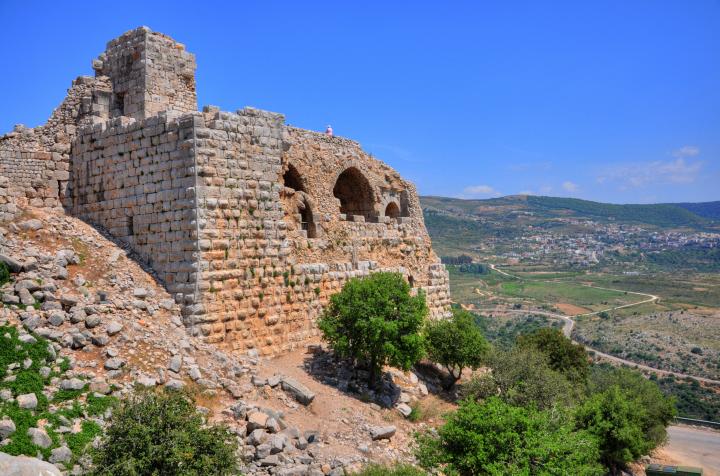
The fortress is located on a high cliff, north-east of the ruins of Banias. This view is seen from the south-western tower of the Crusader city, looking up to the fortress above.

A much closer view, from the road that climbs up to the fortress, is shown below. The left side is the south-western tower, while the right side is the eastern tower. The distance between both ends is 420m, while its maximum width is 150m.

The modern entrance to the fortress is via a service road, located on the western side. The parking area is located on the western side of the walls.

These high walls and towers protected this weaker side of the fortress. The top side of the walls and tower were knocked down by a massive earthquake in the 18th C.

A trail leads up from the parking place to the north-western tower. The path reaches the far (hidden) side of the tower, where a secret entry was located.

The secret passage leads up through the exterior section of the northern wall. It was used for launching surprise attacks, or a way to flee the attacked fortress.

The stairs lead up to the north-western gate.

The end of the secret tunnel is seen below.

The western gate, which was the rear gate to the fortress, is located near the tunnel opening. It is protected by the tall tower .

On the side of the entrance is a large water cistern which supplied water to the visitors and guards. A convenience chamber is located on the right for the convenience of the guards.

A closer view of the western gate is observed below. Notice that some of the stones in the arch above the entrance were displaced. This is a result of the earthquakes that shocked the site during the years.
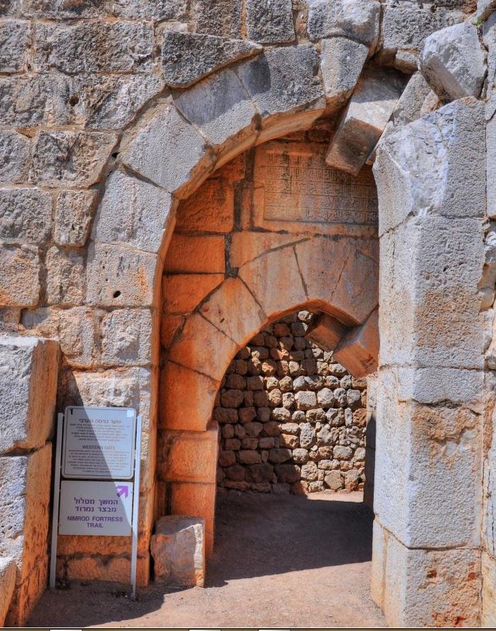
An inner gate is located behind the first one, with a section of the second floor seen above the arch. In 1275 the Mamelukes added this second floor above the gate and the exterior entrance was blocked.

The interior side of the north-western tower is shown below. The steps led to the second floor, which is now in ruins.

Another view of the north-western tower, as seen from the top of the walls. The valley below is the Guveta stream, which flows to Banias. Notice the deep gorge, which is 300m lower than the fortress.

Megalithic blocks with later decorated inscription dated to the Mameluke Sultan Baybars (1275) is located near the tower. It was originally located on the inner side of the tower, but an earthquake - which devastated most of the fortress - caused it to fall and smash to pieces.

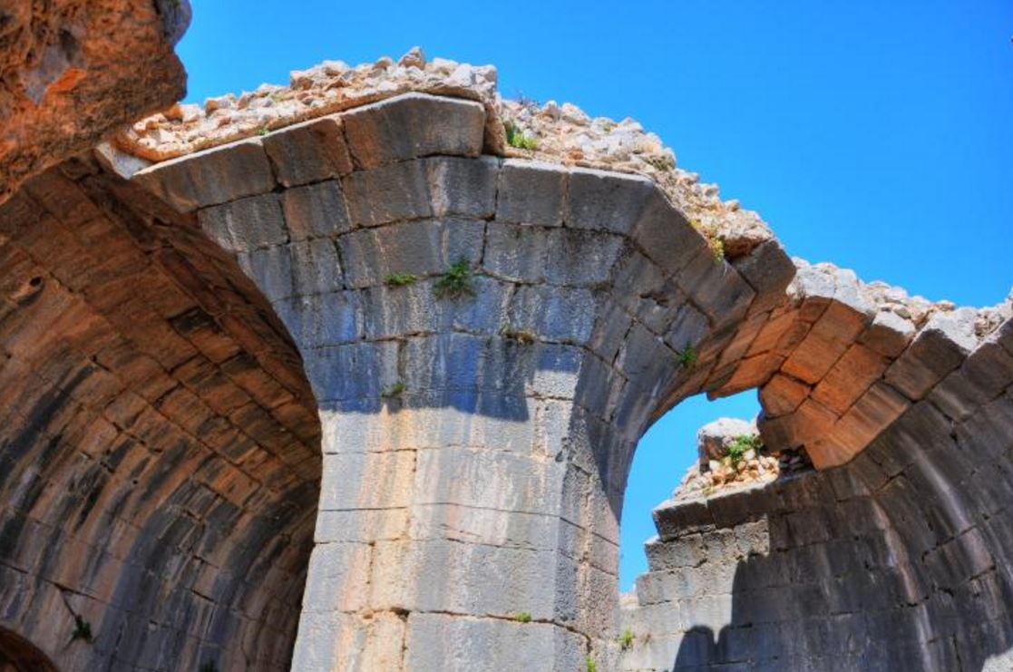
The northern tower is better preserved than the previous tower.

It includes a central hall with archers' slits around its walls (called "embrasure", meaning widening).

Another view of the ceiling, with light coming from the roof.

A staircase ascends to the roof which is used as an observatory.

The Northern tower is seen in the picture below at the edge of the northern wall.

The fortress is long (420m) and narrow (150m max), and there is a long gap in the middle between the two sections of the fortress.The photo below shows the higher eastern section in the background. The southern wall and its 7 towers are on the right side.

The northern wall has no towers in the center; the defense relies on the natural protection (the deep Guveta valley, 300m lower than these walls).

The Nimrod Donjon is the earliest construction phase after the Crusaders, and built in 1227/1228 by Sultan al-Aziz Uthman. The Mamlukes added round towers around the structure during the times of Baybars and Bilik (1260-1277). The total size of the Donjon/Keep is 45m x 65m.

A dry moat, hewn into the bedrock, is located on the western side of the Donjon, making it harder for the enemy to attack the inner fortress after breaching the external walls. It was crossed by a wooden draw bridge.

The steps leading up to the Donjon are seen in the picture underneath. The remains of the arches of the gates, which locked out the Donjon from the rest of the fortress, are visible.

On top of the Donjon is an observatory balcony, with great views of the area around the fortress.

The views from the top of the Donjon are breathtaking panoramas of Mt. Hermon, the Golan heights (seen below), and the Hulah valley.

The walkway surrounds the inner side of the Donjon, where remnants of arches of a ceremonial hall and additional halls were found.

A view of the lower western section is viewed from the tower. In the background is the valley of Hulah, once covered by a great lake.

On the north side, a lower structure is located near the entrance to the Donjon, overlooking the valley.

A view from the Donjon towards the east is seen below. Six square towers are located around the walls of the Donjon.

The entrance to the Donjon is located on its northern side, which can be seen below. A section of an inscription is embedded in the wall.

The south eastern side of the fortress is seen below from the park's entrance. The round tower on the right is the eastern tower. A path (for good hikers) leads from the tower down to the spot where the photo was taken.

The eastern tower is seen from the balcony on top of the Donjon.

A trail passes through an opening in the eastern tower, and descends to the foothills near the park's entrance.

A number of towers (7) were constructed along the southern walls - four towers are square, and three are round. This side was the main gate entrance, and the access road reached below the walls. This required the defense measures to be stronger.
The main entrance was through a gate in the southern wall, 75m south of the Donjon. It is now in ruins.

The most eastern tower, located on the side of the tall Donjon, is round. Stairs lead to the roof, which is now missing.

A view of the interior of this tower is seen below. The arch supported the second level.

A view of the eastern side of the tower is seen in the next picture. You can see how tall the walls are above the southern side.

The following photo shows another view from the tower - towards the south-western corner tower. The access road to the parking place is seen ascending along the south wall.

A square tower is located to the west of the previous tower. Its purpose was to protect the main gate.

The entrance to this tower is seen below. It also had two floors and the steps along its eastern wall led up to the roof.

The interior walls of the tower are seen in the following picture.

The archers' slits around its walls ("embrasure"):

A view overlooking the ruined wall and another round tower:

The "Beautiful" tower, a round tower closer to the western edge, was constructed by the Mamelukes Baybars and Bilik in 1260-1277. The structure projects from the wall in a semicircle shape, allowing the defending archers a clear view of the enemy climbing up the walls.

The next photos is a closer view of the entrance to the tower.

Steps on both sides of the door ascend to its missing second floor.

The tower earned its name from the beautiful interior architectural design and its use of fine stone cutting. The inside is octagonal shaped, of which two sides were joined together leaving it with seven sides.

Another view of this smart design:
The archers' slits around its walls ("embrasure") are also outstanding in quality:

A convenience chamber is located on the right for the convenience of the northwest tower.

The eastern side of the fountain, where a small faucet is embedded into the wall of the reservoir, is shown below.

The faucet is seen in detail below.

On the southern wall is a basin and a water outlet.

A passage to the south-west tower and the large water reservoir is shown below. Stone water vessels were used to store the water fetched from the fountain.

This large (9m x 25m x 7m) water reservoir stored rainwater and supplied drinking water. Steps on the northern side descend from the ground level down to the reservoir.

The walls are plastered and the whole reservoir was once covered by a roof.

A refreshing view from the northern side ... Notice that at the southern side the wall was breached and is now easily accessed from that side. In Medieval times the reservoir filled up with water in order to keep the defenders alive for long months of siege.

The south-western tower is located on the corner of the fortress, on the south side of the service road.
A view of the south-eastern corner of the tower is seen below. This external shell was added as a shell around the inner, Crusader square tower.

The interior of the tower is seen in the following photo.

A spiral staircase descends to the lower southward facing rooms.

The interior of the tower was constructed by the Crusaders (1129-1132) while the external shell was added by the Arabs (1230) and the Mamelukes (1260-1277).

A great view of the southern wall and towers is seen from this end.

Western tower:


No comments:
Post a Comment